
Skip to content

Cookie settings

Choose which purposes you consent to. Nothing is on beforehand, and nothing is fetched until you save. You can change or withdraw your consent at any time via “Cookie settings” at the foot of the page.

Cookie settings

Make the site work and remember the choice you make here. They cannot be switched off, and they do not require your consent.

Show services (1)
  • HLM Landmåling · Provider: HLM Landmåling A/S
    Remembers your cookie choice so you are not asked again on every page.
    hlm_consent (12 months)

Show content we pull in from others - maps, video and 360° views. Without them you get a placeholder you can click if you want to see the content anyway.

Show services (2)

Measure which pages get read, so we can make them better. Not used to recognise you as a person.

Let advertising tools measure what happens after a click on an ad, and follow you across websites.

Show services (1)
  • KOMO Evolution360 · Provider: KOMO A/S
    Measures which ads and sources lead to enquiries: where you came from, and whether you call, write or send the contact form. The content of the form is also sent to KOMO.
    _evo_visit (Persistent (localStorage)), _evo_ref (Persistent (localStorage)), _evo_gclid (Persistent (localStorage)), _evo_keyword (Persistent (localStorage)), _pk_id.* (13 months), _pk_ses.* (30 minutes), _pk_ref.* (6 months)
    KOMO A/S (opens in a new window)
Land surveying & setting-out

Services - 01

Land surveying & setting-out

Setting-out and surveying for civil works and construction - from the position of the foundation to marking walls, columns, doors and pipes. Fast response, so the build never stalls.

01 - Surveying Overview

What we deliver

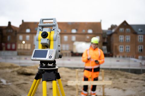
We set out and survey with total station and GNSS - precise, documented and ready to build from. From the first control network to the ongoing setting-out of walls, columns, penetrations and installations, we keep the build on track, day by day - and with rail surveying and precision levelling we also cover the railway and the tasks where height data must be right to the millimetre. See projects on motorways, railways and high-rise.

  • Setting-out
  • Surveying
  • Rail surveying
  • Levelling
  • Control network
  • Site plan
How we work Surveying

01

Setting-out for buildings

Whether you are planning a private home, a commercial building or an extension, we can help with the planning. We make sure building heights, distances to boundaries and other key factors are strictly observed, so your build follows the approved plans.

Where boundaries on the property need to be determined, we work with De Fakto consulting chartered surveyors in HLM Group - read about boundaries, subdivision and other chartered surveyor services. We also prepare a site plan showing the exact position of the boundary along with buildings and other relevant features.


02

Setting-out for civil works

On road construction, utility lines or other infrastructure work we make sure the setting-out is accurate from the start, so the work can be carried out efficiently and precisely. We take schedules and project requirements into account, and careful initial setting-out gives a solid basis for everything that follows.

  • Drainage: optimal water run-off and drainage
  • Kerbs: correct alignment and adjustment of levels
  • Extensions: safe integration with the existing building
  • Roads: correct road alignment and gradient to the planned specifications

03

Control points and control networks

The control network is the foundation for precise measurement on every civil and construction project. We handle the whole process, from initial planning to establishing, surveying, computing and maintaining the control points. With extra-durable markers such as screw pegs, concrete foundations and pillars, the network holds precise coordinates for the whole project period - through the weather and the daily wear of the build.

A strategically placed control network can be extended with base stations and GPS systems for machine control of dozers and excavators. With check points in the network, heights and positions can be monitored and adjusted as the job goes.

04

Site plans and terrain surveys

The site plan gives a clear overview of built structures and boundaries, so every party shares the same understanding of existing conditions. The terrain survey gives a detailed picture of the existing ground, which is essential for drainage, foundations and fitting buildings into the landscape - especially where even small changes in level or gradient matter a great deal.

Large and hard-to-reach areas we map quickly with drones carrying high-resolution cameras and RTK.

05

On site locally from 7 am

With offices and surveyors all over Denmark, we are always present locally. Our team is on site by 7 am at the latest, ready to work with the people on the build. Once the survey is done, you get full documentation: detailed drawings and models you can use directly in your work.

Contact Surveying

Your contacts

Other services One team for the whole data chain

What else we do

Machine control

We prepare setting-out data and machine-control files - and load them, including via secure remote access - so the machines hit the mark first time.

Read more - Machine control

Georadar & utility detection

GPR scanning locates pipes, cables and objects underground - without digging, across large areas and confined sites alike.

Read more - Georadar

3D laser scanning

Millimetre-accurate point clouds with our static Z+F Imager 5016 - and fast SLAM scanning with the CHCNAV RS10 when speed counts. Buildings, terrain, civil works.

Read more - 3D scanning

CAD, data & documentation

We turn data into drawings, volume calculations and as-built - and deliver complete final documentation that holds up in disputes and under warranty.

Read more - CAD & data

Monitoring & surveillance

Continuous monitoring of movements, settlements and deformations on structures, buildings and infrastructure - so deviations are caught before they become damage.

Read more - Monitoring

Drone surveying

We map large areas from the air with photogrammetry and an RTK drone and generate precise 3D models in Pix4D - supplemented by LiDAR where the airspace allows.

Read more - Drone surveying

Chartered surveyor services

Boundaries, subdivision, condominiums, easements and land registration - we deliver the cadastral and legal services together with our sister company De Fakto.

Read more - Chartered surveyor

Contact

How can we help?

Got a question or a task in mind? Call or write - we'll get back to you within one working day.

+45 32 12 51 15 or fill out the form

Ask us

Brief & no obligation - you'll hear from us soon.