Skip to content

Cookie settings

Choose which purposes you consent to. Nothing is on beforehand, and nothing is fetched until you save. You can change or withdraw your consent at any time via “Cookie settings” at the foot of the page.

Cookie settings

Make the site work and remember the choice you make here. They cannot be switched off, and they do not require your consent.

Show services (1)
  • HLM Landmåling · Provider: HLM Landmåling A/S
    Remembers your cookie choice so you are not asked again on every page.
    hlm_consent (12 months)

Show content we pull in from others - maps, video and 360° views. Without them you get a placeholder you can click if you want to see the content anyway.

Show services (2)

Measure which pages get read, so we can make them better. Not used to recognise you as a person.

Let advertising tools measure what happens after a click on an ad, and follow you across websites.

Show services (1)
  • KOMO Evolution360 · Provider: KOMO A/S
    Measures which ads and sources lead to enquiries: where you came from, and whether you call, write or send the contact form. The content of the form is also sent to KOMO.
    _evo_visit (Persistent (localStorage)), _evo_ref (Persistent (localStorage)), _evo_gclid (Persistent (localStorage)), _evo_keyword (Persistent (localStorage)), _pk_id.* (13 months), _pk_ses.* (30 minutes), _pk_ref.* (6 months)
    KOMO A/S (opens in a new window)
Monitoring & surveillance

Services - 06

Monitoring & surveillance

Continuous monitoring of movements, settlements and deformations on structures, buildings and infrastructure - so deviations are caught before they become damage.

06 - Monitoring Overview

What we deliver

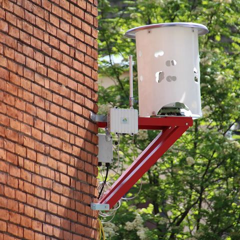
When a build or structure needs to be followed over time, we deliver monitoring together with our sister company SMT Nordic - the Nordic leader in monitoring of structures, climate and infrastructure. Sensors and automated measurements track movements, settlements and deformations in real time, watched from a control centre around the clock, all year. We help you all the way onward.

  • Deformation
  • Settlements
  • Inclinometer
  • Vibration monitoring
  • Monitoring
  • Control centre 24/7

On to SMT Nordic (opens in a new window)

How we work Monitoring

01

Monitoring in, below and above ground

Monitoring is the core competence of our colleagues at SMT Nordic. Together, HLM and SMT Nordic monitor settlements, vibrations and deformations - continuously and automatically on, among other things:

  • Buildings
  • Terrain
  • Railway tracks
  • Bridges
  • Quays
  • Secant piles

02

What our monitoring set-up gives you

The equipment includes inclinometers, extensometers, tiltmeters, load cells, strain gauges, groundwater measurement, liquid levelling and crack meters. On top of that we handle all data management and server solutions.

The monitoring rests on the same control network and surveying the rest of the project is built on.

  • Extensive construction supervision
  • An overview of risks and the chance to intervene in time
  • 24-hour monitoring
  • Direct access to all data
Frequently asked questions Monitoring

What do customers ask about?

How do you monitor settlement and deformation?

Monitoring is delivered together with our colleagues at SMT Nordic - continuously and automatically on buildings, terrain, railway track, bridges, quays and secant piles. You get 24-hour monitoring and direct access to all data, measured with inclinometers, extensometers, tiltmeters, load cells, strain gauges, groundwater sensors, liquid levelling and crack meters.

Contact Monitoring

Your contacts

Other services One team for the whole data chain

What else we do

Land surveying & setting-out

Setting-out and surveying for civil works and construction - from the position of the foundation to marking walls, columns, doors and pipes. Fast response, so the build never stalls.

Read more - Surveying

Machine control

We prepare setting-out data and machine-control files - and load them, including via secure remote access - so the machines hit the mark first time.

Read more - Machine control

Georadar & utility detection

GPR scanning locates pipes, cables and objects underground - without digging, across large areas and confined sites alike.

Read more - Georadar

3D laser scanning

Millimetre-accurate point clouds with our static Z+F Imager 5016 - and fast SLAM scanning with the CHCNAV RS10 when speed counts. Buildings, terrain, civil works.

Read more - 3D scanning

CAD, data & documentation

We turn data into drawings, volume calculations and as-built - and deliver complete final documentation that holds up in disputes and under warranty.

Read more - CAD & data

Drone surveying

We map large areas from the air with photogrammetry and an RTK drone and generate precise 3D models in Pix4D - supplemented by LiDAR where the airspace allows.

Read more - Drone surveying

Chartered surveyor services

Boundaries, subdivision, condominiums, easements and land registration - we deliver the cadastral and legal services together with our sister company De Fakto.

Read more - Chartered surveyor

Contact

How can we help?

Got a question or a task in mind? Call or write - we'll get back to you within one working day.

+45 32 12 51 15 or fill out the form

Ask us

Brief & no obligation - you'll hear from us soon.